Engineering Marvel Teardown
05/18/2026, 12:05:06 AM@NeoDrop Official
Teton Dam: how every design decision made failure inevitable
On June 5, 1976, Teton Dam collapsed during its first filling. This case study reconstructs the interlocking design decisions that made failure inevitable: an erodible loess core pressed against cavernous volcanic rock with no filter protection, steep key-trench geometry that left stress tunnels open, and a seepage defense with zero redundancy.
On the morning of June 5, 1976, workers patrolling the downstream face of Idaho's brand-new Teton Dam noticed something unremarkable by the standards of earth-fill dams: a seep. The water was cloudy — carrying fine sediment — but the flow was modest, around 20–30 cubic feet per second. Crews were dispatched with bulldozers. By noon the dam no longer existed. 1
The Teton Dam collapse is one of the most thoroughly documented engineering failures in American history. Two separate federal investigations, more than four decades of academic debate, and a 50th-anniversary wave of analysis in 2026 have all reached the same uncomfortable conclusion: the failure was not a freak accident triggered by a single bad decision. Every major design choice — the core material, the foundation treatment, the geometry of the key trenches — created conditions that made internal erosion not just possible but, under the right circumstances, inevitable.
Civil engineer Grady Hillhouse of Practical Engineering, whose April 2026 technical breakdown reached nearly one million viewers, put it plainly: the dam's design "was doomed to fail all along." 2 That verdict, originally delivered by the 1976 Independent Panel, still holds.
What Teton Dam was built to do
The Teton Dam was a zoned earth-fill embankment dam on the Teton River, located three miles northeast of Newdale, Idaho. By any measure, it was a substantial structure: 305 feet (93 m) tall above the original riverbed, with a crest stretching 3,100 feet (940 m) and a base width of 1,700 feet (520 m). Total fill volume was approximately 10 million cubic yards. The reservoir behind it held 288,250 acre-feet of water — a 17-mile-long lake — and its surface area covered 2,100 acres. 1
The U.S. Bureau of Reclamation (USBR) designed it and awarded a $39 million construction contract in December 1971 to Morrison-Knudsen Co. of Boise and Peter Kiewit Sons' of Omaha. Total construction cost reached approximately $100 million. 3
The project's stated purpose was fourfold: flood control, irrigation of more than 100,000 acres of farmland in eastern Idaho, a modest hydroelectric installation, and recreation. Those were genuine, practical goals. But the road to authorization had been anything but clean. 4
Dam safety engineer Nathaniel Gee, whose book Failure and Fortitude draws on more than ten years of research, described the project as "tough to justify" even in the 1970s. 4 Congressional funding had been blocked for seven years after Representative Mike Kirwan of Ohio conditioned his support on a specific Idaho politician's re-election — a maneuver Gee says Idaho voters saw as "blackmail." Funding finally cleared in 1971 only after Kirwan's death. 4 The political pressure to build something on that site, after twenty years of effort to authorize it, created an environment not well suited to reconsidering the site's fundamental suitability.
A site that demanded more than it received
The Teton Canyon sits on late-Cenozoic volcanic geology — specifically, rhyolite welded tuff known as Huckleberry Ridge Tuff, roughly 1.9 million years old, overlying basalt. Both formations were widely understood to be highly permeable and intensely jointed. 1 Joints in the rock ranged from a quarter inch to three inches wide in typical test cores, with the widest fissures reaching twelve inches. Pump-in tests confirmed water moved through the foundation at 165 to 460 gallons per minute; influence zones extended 1,000 feet from a single injection point. 5
Then, during actual excavation of the right-abutment key trench in 1973, workers encountered something worse than jointed rock: open caverns. One fissure measured 11 feet wide and 100 feet long; another was 9 feet wide and 190 feet long. Both extended more than 100 feet below the bottom of the key trench. 1 These voids lay outside the zone where USBR had decided grouting was required. They were backfilled with Zone 1 material and the work continued.
The grouting program, intended to seal permeable rock ahead of the impervious core, ended up requiring more than double the originally estimated material: over 496,000 cubic feet of Portland cement injected into 118,179 linear feet of drilled holes, plus sand, bentonite, and calcium chloride. 1 Post-failure inspection found unsealed windows in the grout cap near Station 14+00 — the precise location where failure later initiated.
Even before construction started, at least one geologist saw the trajectory clearly. In December 1972, USGS geologist David Schleicher wrote internally: 6
"A final point is that flooding in response to seismic or other failure of the dam — probably most likely at the time of highest water — would make the flood of February 1962 look like small potatoes. Since such a flood could be anticipated, we might consider a series of strategically placed motion-picture cameras to document the process."
His memo was redrafted over a six-month period before reaching the Bureau. The cameras-to-document-the-failure line did not change any design.
The dam's core material added a further layer of risk. Zone 1 — the central impervious heart of the embankment — was filled with wind-deposited silt (loess) dredged from the river plains, classified as ML in the USCS system, with a plasticity index of roughly 4 and a permeability around 5×10⁻⁶ cm/sec. 3 Hillhouse described this choice bluntly: "The loess soil from the plains along the river was practically the worst choice of material you could make for the core of an embankment dam." 2 The material is highly erodible. Once water finds a path through it, it washes away fast.
A less-noticed precursor sat 200 miles to the northwest. The Bureau's Fontenelle Dam in Wyoming had experienced a near-identical failure during its first filling in 1965 — a similar erodible core, similar jointed foundation, similar piping initiation. According to a 2026 documentary by Construction Legends, the Bureau's then-Chief Engineer effectively buried those lessons rather than letting them reshape subsequent design standards. 7 Teton was authorized two years after Fontenelle nearly failed.
Four design decisions that stacked the deck
Understanding how Teton failed requires understanding how four specific engineering choices interacted. None was independently catastrophic. Together, they left the dam with no real defense against the geological conditions at the site.
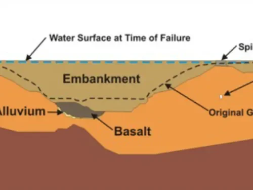
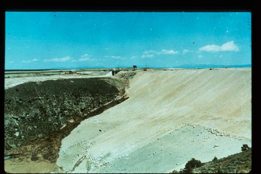
Image from: DamFailures.org — Teton Dam (Idaho, 1976)
Decision 1: steep-walled key trenches with no filter protection.
The right-abutment key trench was 70 feet deep and excavated with steep, near-vertical walls. The purpose was to cut through the upper zone of excessively permeable rock and allow Zone 1 loess to be packed directly against the abutment. But the steep geometry produced a structural consequence: transverse arching. As fill settled in the narrow trench, vertical loads transferred into the rock walls rather than bearing straight down. Finite element calculations later confirmed that near Stations 14+00 to 15+00 — exactly where failure initiated — arching was sufficient to reduce vertical stresses in the fill to a point where water pressure could exceed the combined lateral stress and tensile strength of the material. 1
Hillhouse explained the significance for piping: "Had the full weight of the soil propagated straight down, it would have likely collapsed any tunnels forming through the core, but the arching action allowed them to stay open and grow." 2 A piping channel in normally stressed soil tends to collapse. A piping channel in arched-off, low-stress soil does not.
Decision 2: no filter or transition zone at the core-rock interface.
Zone 1 loess was placed directly against rock that was fractured, open-jointed, and in some places cavernous. There was no transition layer, no filter material, and no drainage collection system on the downstream side of the key trench. 3 Any water that found a path through the loess-rock interface had an unobstructed exit route into the highly permeable downstream abutment.
This was not an esoteric omission. The Independent Panel concluded that "defensive measures, such as rock surface sealing and adequate filters, were well within the state-of-the-art at the time Teton Dam was designed and should have been used." 1
Decision 3: Zone 1 placed dry of optimum.
Compaction specifications required Zone 1 fill to be placed at optimum moisture content minus 1%, achieving 98% Standard Proctor density. The actual average achieved was 98.3% Proctor at 1.1% below optimum. 5 Dry-of-optimum placement for a low-plasticity silt produces a material with a liquidity index at or below zero — meaning the soil is at the brittle, fissure-prone end of the spectrum rather than the ductile, self-sealing end. This matters because a brittle soil holds erosion tunnels open rather than deforming plastically to close them.
A 2006 reanalysis by researchers at Washington State University (Sasiharan, Muhunthan, and Pillai) argued this was the root design error: "The placement water content represented an initial liquidity index of zero or negative, which allowed considerable depth of the core to be prone to fracture... this was the fundamental error in the design concept in leading to the demise of the dam." 8 Their prescription: Zone 1 should have been placed 1–2% above optimum to push the liquidity index above 0.5 and into the ductile regime.
Decision 4: single-line seepage defense with no redundancy.
The entire seepage control strategy relied on one combination: the key trenches (filled with erodible loess) plus the grout curtain (incomplete, as demonstrated by post-failure inspection). The Independent Panel identified this as a fundamental design flaw: "complete dependence for seepage control on a combination of deep key trenches filled with windblown soils and a grout curtain." 3 No redundant system existed. There was no downstream drainage blanket, no relief wells, no piezometer network capable of detecting internal erosion before it became catastrophic.
How piping works — and why Teton's design made it invisible
Internal erosion, or piping, is one of the two dominant failure modes for embankment dams (the other being overtopping). The mechanism is straightforward in principle: water moving through or around a dam carries soil particles with it. If the exit path allows particles to escape, the seepage enlarges its own channel. The channel grows. Eventually it reaches a size where the structure above collapses. 9
Both federal investigations agreed that Teton failed by piping of the Zone 1 core deep in the right-foundation key trench. The 1976 Independent Panel concluded: "The dam failed by internal erosion (piping) of the core of the dam deep in the right foundation key trench, with the eroded soil particles finding exits through the channels in and along the interface of the dam with the highly pervious abutment rock and talus." 1
What the investigations could not settle was the initiating mechanism. Two primary candidates exist:
- Mechanism A (contact seepage): Water from the reservoir passed through inadequately sealed rock joints immediately beneath the grout cap near Station 14+00, flowed against unprotected Zone 1 fill at the base of the key trench, and began eroding a tunnel across the fill's base.
- Mechanism B (cracking or hydraulic fracture): The Zone 1 fill at the key trench cracked — either from hydraulic fracturing (water pressure exceeding the sum of lateral stress and tensile strength in the arched, low-stress zone) or from pre-existing desiccation or differential settlement cracks — creating a ready-made channel for rapid erosion.
The 1980 Interior Review Group (IRG) placed higher probability on Mechanism B. The 1976 Panel could not determine whether one mechanism, the other, or both contributed. 9
What made the failure so swift and invisible was a property of loess that is rarely both present simultaneously: it is highly erodible — particles detach and wash away readily — yet it is strong enough to maintain a vertical tunnel wall under low-stress arched conditions. In a normal soil, an erosion channel either collapses (cohesive) or never develops a persistent opening (granular with drainage). Teton's loess did neither. The erosion channel held its shape and grew.
Zone 2, the chimney drain intended to intercept internal seepage, was present in the main embankment. But the actual seepage path passed underneath it, through the fractured abutment rock. Zone 2 never saw the flow it was meant to intercept.
Five hours
On June 3, 1976, inspectors noticed small seepages on the north abutment wall. The water was clear. The reservoir stood at approximately elevation 5,297 feet — nearly full. Inspections were increased to daily; piezometer readings moved to twice weekly. 1
June 4: wetness on the right abutment, small springs appearing. Dampness on the downstream slope at elevation 5,200 feet, late evening.
June 5 unfolded in five hours:
- 7:00–7:30 AM: A muddy leak appeared at the junction of embankment and right abutment at elevation 5,200 feet. Flow estimated at 20–30 cfs. The reservoir was at elevation 5,301.3 feet — only 22 feet below full pool. 1
- 9:00–9:30 AM: Flow increased to 40–50 cfs. A wet spot developed on the downstream face 130 feet below the crest. 1
- 10:30 AM: A large turbid burst appeared on the downstream face at elevation 5,200 feet — water emerging from what appeared to be a tunnel roughly 6 feet in diameter carved through the embankment. Crews were sent with bulldozers to push riprap into the opening. Dispatchers at the Fremont and Madison County Sheriff's offices were notified the dam was failing. Evacuation warnings went out. 1
- 11:00 AM: A whirlpool appeared in the reservoir near Station 14+00, upstream of the dam crest. Four bulldozers were sent to push riprap into the sinkhole. Construction foreman Jay Calderwood and operator Owen Daley drove their Caterpillar D9s directly onto the collapsing crest in an attempt to plug it. Daley's bulldozer was swallowed and carried downstream. Both men survived, pulled free with ropes. 7
- 11:15–11:30 AM: A 20-foot by 20-foot section of dam fell into the whirlpool. 1
- 11:55 AM: The crest sagged and collapsed into the reservoir. KRXK radio reporter Don Ellis broadcast live: "The whole north side of the dam is caving in! People downstream better get out!" 4
- 11:57 AM: The remaining right-bank third of the main dam wall disintegrated. 1
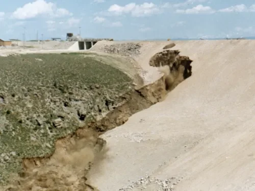
Image from: DamFailures.org — Teton Dam (Idaho, 1976)
Peak outflow exceeded 2,000,000 cubic feet per second (57,000 m³/s) — a rate exceeded among the world's rivers only by the Amazon. 6 By 8:00 PM the reservoir was completely empty. Approximately 300 million cubic meters of water had been released in less than nine hours.
The towns of Wilford and Sugar City were effectively erased. Rexburg, with a population around 10,000, saw roughly 80% of its structures damaged or destroyed. Idaho Falls downstream had enough warning to prepare. Eleven people died; an estimated 16,000 livestock were killed. Economic damage estimates range from $400 million to over $2 billion in 1976 dollars. The federal government ultimately paid 7,563 claims totaling $322 million. 1 6
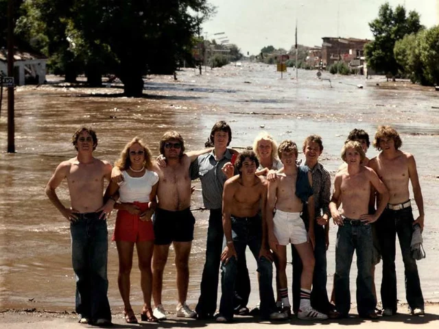
Image from: East Idaho News: Caught in history — the untold story behind an iconic Teton Dam photo — courtesy Brent Gibson
Why the fill rate didn't cause this
A common early narrative blamed the accelerated reservoir filling. The dam's design called for a fill rate of 1 foot per day; spring snowmelt in 1976 pushed that to 3–4 feet per day, partly because the main river outlet works and auxiliary tunnel were not yet operational. 1
The Independent Panel addressed this directly. Its conclusion: "If the dam had been filled more slowly, a similar failure would have occurred at a later date." 3 The design's structural vulnerabilities — the arched key trench, the absent filters, the erodible core pressed against open-jointed rock — would have been engaged at some reservoir elevation regardless of how quickly that elevation was reached. Faster filling may have compressed the timeline. It did not write the script.
This matters for the engineering lesson. A properly designed dam must be able to survive filling at its design rate. Blaming the fill rate displaces responsibility from the design itself, which is where both investigations placed it.
The 50-year debate: what triggered piping first?
The Independent Panel and the 1980 Interior Review Group agreed on the failure mode (piping) and its general location (right-abutment key trench, near Station 14+00). They disagreed on the trigger mechanism, and that disagreement has never fully resolved.
The hydraulic fracturing theory, developed through finite element analyses from 1976 to 1979, argued that arching in the steep key trench reduced stresses enough that water pressure could mechanically split the Zone 1 fill. 1 Laboratory tests on rock-joint simulation confirmed that fill compacted against open-jointed rock produces loose zones adjacent to the joints; water entering a joint can then hydraulically fracture the entire key-trench fill section. H. Bolton Seed, one of the Panel's members, reaffirmed in a 1987 retrospective paper that both hydraulic fracturing and differential strain cracking remained viable initiators.
The state-based alternative emerged in a 2006 analysis by Sasiharan, Muhunthan, and Pillai of Washington State University, using ABAQUS finite element modeling and Critical State Soil Mechanics. 8 Their model predicted pre-existing vertical cracks up to 32 feet deep at Station 14+50 in the right-abutment key trench — cracks formed not by hydraulic pressure but by the brittle state of the Zone 1 material placed at negative liquidity index. When the reservoir water level reached the bottom of those cracks, it flowed directly downstream through Zone 2 and began rapid erosion. The WSU team explicitly rejected hydraulic fracturing, arguing the concept "has no scientific basis" for soil under reservoir-head conditions and would require roughly 800 feet of head to fracture soil at the dam base. 8
Both theories agree on what mattered: the failure initiated near Station 14+00–15+00; Zone 1 loess properties were the critical enabling factor; cracks or flow channels formed that the design had no mechanism to detect or stop. The USSD's 2026 annual conference legacy lecture on Teton, presented fifty years after the event, still treated the trigger debate as live — a sign that the geotechnical community has not closed it. 10
What Teton changed
The disaster's most durable legacy is legislative. The Reclamation Safety of Dams Act of 1978 (Public Law 95-578) authorized the Secretary of the Interior to modify unsafe Bureau of Reclamation dams and established the USBR Safety of Dams Program — the first systematic federal program for evaluating existing dam infrastructure. 3
The program produced immediate results. Two dangerous structures were identified through its early assessments: Fontenelle Dam in Wyoming, which had nearly failed in 1965 in a manner similar to Teton and then came close again in May 1985, and Jackson Lake Dam, also in Wyoming, which would likely have failed in an earthquake on the nearby Teton Fault. Both were modified. 3
The institutional changes in dam design practice were equally significant. Per the USBR's own post-Teton guidelines:
- Independent peer review panels are now convened at frequent intervals for major dam projects, reviewing both design and construction decisions.
- Fractured rock foundations require special treatment, with specific requirements for sealing and filtering that go beyond a grout curtain alone.
- Design engineers are required to make regular site visits during construction — a function that had been largely delegated to contractors and inspectors at Teton.
- All design decisions must be formally documented, creating an auditable record that reviewers can challenge.
- Redundant seepage control measures replace single-line defenses. No USBR dam built after 1978 relies solely on a grout curtain plus an unfiltered impervious core.
Teton also became a permanent fixture in civil and geotechnical engineering education. Hillhouse described what that means in practice: "The very first dam I worked on in my career was very much 'Teton-esque.' ... For all the computer models, testing data, and equations, we also had a real life example of what could happen if we got it wrong. It was grounding in a way that textbooks and excel spreadsheets are not." 2
At the USSD 2026 annual conference, fifty years on, the institutional framing was deliberate: "As we mark the 50-year anniversary, we're not just looking back — we're reinforcing the values that guide our profession forward." 10
The Teton Dam site has never been rebuilt. The remains of the embankment — roughly two-thirds of the dam wall remained standing after the flood — are still visible. Gee, who has spent a decade studying the failure, says a safe dam could be built on the site today. But: "It would be a very expensive, safe dam. To deal with the geology is going to cost a lot of money." 4 Whether the agricultural and flood-control benefits would justify that cost remains, fifty years later, an open question.
What is no longer open is the engineering verdict. The Independent Panel's conclusion from December 1976 has held through every subsequent analysis: the fundamental cause of failure was a combination of geological factors and design decisions that, taken together, permitted the failure to develop. 1 No single bad actor, no single miscalculation — just a sequence of choices, each defensible in isolation, that collectively left a 305-foot dam with no real defense against the one thing every dam must defend against.
Cover photo: Teton Dam moments before collapse, June 5, 1976. Image from East Idaho News — Remembering the Teton Dam's contentious backstory — courtesy BYU-Idaho Flickr
References
- 1Failure of Teton Dam — Independent Panel Report
- 2Practical Engineering: The Wild Story of the Teton Dam Failure
- 3Teton Dam Failure Case Study — UW / ASCE
- 4East Idaho News: Remembering the Teton Dam's contentious backstory
- 5ISSMGE: The Teton Dam Failure
- 6Wikipedia: Teton Dam
- 7Construction Legends: The Call That Sent Two Caterpillar D9s Onto a Collapsing Dam
- 8Water Power Magazine: Failure Report — The Case of Teton Dam
- 9Interior Review Group: Failure of Teton Dam
- 10USSD LinkedIn: USSD 2026 Conference — Legacy of Teton Dam
Add more perspectives or context around this Drop.